Search
Close this search box.

A virtual transmission line runs through the landscape

Share
Constructing a transmission line is a long process, which first sees the light of day on a map, many years before becoming a feature of the landscape. Nowadays, future transmission line rights-of-way can be presented to landowners and partners with the help of 3D modelling.

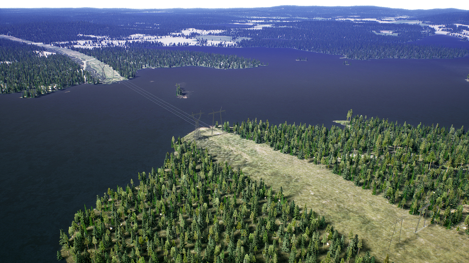
The actual future appearance of various structures can be presented on 3D models, which provide a three-dimensional illustration of a selected location. Fingrid is currently piloting this technology in the environmental impact assessments for its Lake Line from Oulu to Lappeenranta project. The 3D virtual model provides a more visual image of the future transmission line than simply a line on a map.

“The 3D virtual model places the transmission line’s towers into a virtual environment, which is brought to life using artificial elements. Combinations of these give rise to a game-like virtual world, where transmission lines and towers of realistic heights can be viewed from locations such as the back yards of nearby houses,” says Pasi Turunen, Expert at Fingrid.

As regards tower locations, the 3D virtual model does not entirely correspond to the final outcome, as modelling takes place before general planning begins. The final placement of the towers depends on the soil and a number of technical issues that are not all known at the modelling stage. However, the aim of modelling is to create as realistic a view of the future transmission line as possible.

Based on solutions from the world of gaming

Modelling takes several hours of work, but it does not require anyone to climb up a mast. The 3D virtual models produced on computers are based on map data that is publicly available from the National Land Survey of Finland. Unreal Engine 4, a game engine, is used to build the virtual model and present the material placed into the virtual world.

The three-dimensional view brings new landscape aspects to transmission line projects. It is intended for use during the project’s planning and environmental impact assessment phases, as well as the related public consultations. 3D material will also be made available on Fingrid’s website, which may present key locations along the transmission line in the form of short videos.

“The transmission line will travel approximately 300 kilometres, giving rise to a lot of three-dimensional data that is challenging to distribute in its original format. However, the use of 3D virtual models in our work is still in its infancy, so these things will be given greater consideration as we build up more experience. The 3D material that is made more widely available may include important landscapes and densely populated areas,” says Turunen.

Data helps to identify the best tower sites

Datasets are used to examine the potential for construction in different soil types and prepare soil surveys. Thanks to new electronic datasets, it is possible to prepare more precise estimates of the soil in tower sites.

The construction potential of different types of soil is a critical factor for transmission line towers. Soft, wet marshlands and clayey soils are poor locations for building strong foundations. Rock and moraine, on the other hand, are generally ideal for erecting towers.

It sometimes becomes apparent that the soil quality is not good enough only after the location of a transmission line has been decided. Every situation like this is addressed individually. One option for avoiding a bad tower site is to move it parallel to the line.

It is impossible to assess the construction potential of soil visually, as this does not provide any information about the thickness of the surface layer. For this reason, datasets are used to back up the assessment and create a soil survey. In recent years, more such electronic datasets have been made publicly available. They enable Fingrid to gain a more accurate understanding of the soil in tower sites.

Soil information facilitates the planning of tower routes

Computer programs are capable of handling large data masses with ease in order to identify good tower sites. An expanded soil survey model of this type is currently being piloted on Fingrid’s Lake Line project.

More accurate soil data is useful for the general planning of the project and during construction. It enables tower routes to be planned in advance so that they are optimally able to withstand the weight of heavy lifting machinery.

“Current datasets enable better planning decisions to be made and can help to forecast the forthcoming construction costs. In addition, a precise, on-site soil survey is conducted at every tower site and used plan the tower’s foundations,” says Pasi Saari, Expert at Fingrid.

Comments

Leave a Reply

Your email address will not be published. Required fields are marked *